1954 Map of Nanjemoy
USGS Topo · Published 1967About this map
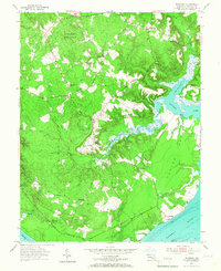
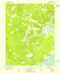
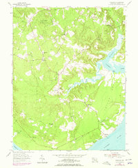
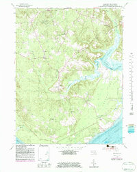
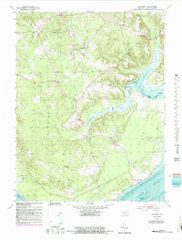
Tayloe Neck dominates the eastern landscape of this mid-century survey, a peninsula defined by the winding course of Nanjemoy Creek as it reaches toward the Potomac River. The interior of Charles County is characterized by dense woodland and small rural centers, notably within the protected bounds of Doncaster State Forest. Settlement patterns are anchored by local institutions, with Durham Ch, St Ignatius Ch, and several schools like Mt Hope Sch serving the scattered community. Along the shoreline, Maryland Point and Riverside mark the southern interface with the river, while inland, the confluence of Beaverdam Run and Hancock Run feeds the tidal marshes and guts that define the region's complex hydrology. The map provides a clear record of the transition from wooded uplands to the marshy lowlands of Thorne Gut Marsh.
Find a feature on this map
27 named features on this map. Tap any name to fly to it.
Don’t see what you’re looking for? This feature index may not catch every label — zoom into the map to look around manually.
Map Details
Editions of this 1954 Nanjemoy Map
5 editions found
Other maps of this area

1889 · Fredericksburg
USGS Topo · 1:125,000

1890 · Mt. Vernon
USGS Topo · 1:125,000

1891 · Mt. Vernon
USGS Topo · 1:125,000

1892 · Fredericksburg
USGS Topo · 1:125,000

1894 · Fredericksburg
USGS Topo · 1:125,000

1894 · Mt. Vernon
USGS Topo · 1:125,000

1897 · Mt. Vernon
USGS Topo · 1:125,000

1913 · Indian Head
USGS Topo · 1:62,500
1913 · Nanjemoy
USGS Topo · 1:62,500

1923 · Indian Head
USGS Topo · 1:48,000