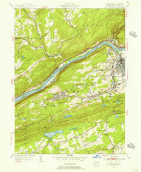
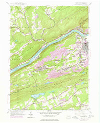
1954 Map of Nanticoke
USGS Topo · Published 1956About this map
The Susquehanna River carves a deep valley between Shickshinny Mountain and the ridge of Penbscot Mountain in this mid-century portrait of Luzerne County. The landscape is defined by the industrial and social infrastructure of the anthracite coal region, where settlements like Glen Lyon, Wanamie, and Alden are linked by the Pennsylvania and Delaware and Hudson railroads. This era of development is marked by a high density of religious and community sites, including St Vladimir Ch and numerous burial grounds such as St Michaels Cem and St Alberts Cem. Further south, the terrain shifts toward more agricultural and recreational use around Lily Lake and Najaka Pond, while the presence of the State Hospital and a Drive-In Theater near Hunlock Gardens reflects the mid-1950s cultural footprint in the Wyoming Valley.
Find a feature on this map
60 named features on this map. Tap any name to fly to it.
Don’t see what you’re looking for? This feature index may not catch every label — zoom into the map to look around manually.
Map Details
Editions of this 1954 Nanticoke Map
5 editions found
Other maps of this area

1891 · Wilkesbarre
USGS Topo · 1:62,500

1891 · Harveys Lake
USGS Topo · 1:62,500

1893 · Harvey Lake
USGS Topo · 1:62,500

1893 · Pittston
USGS Topo · 1:62,500

1894 · Shickshinny
USGS Topo · 1:62,500

1894 · Wilkesbarre
USGS Topo · 1:62,500

1943 · Scranton
USGS Topo · 1:125,000

1946 · Sybertsville
USGS Topo · 1:31,680

1946 · Nanticoke
USGS Topo · 1:31,680

1946 · Shickshinny
USGS Topo · 1:31,680