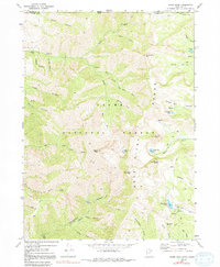
1969 Map of Naomi Peak
USGS Topo · Published 1991About this map
Naomi Peak serves as the prominent high point in this 1969 topographic study of the Bear River Range, situated along the border of Franklin Co and Cache Co. The landscape is defined by the high-elevation basin of the Cache National Forest, where a network of trails and 4WD tracks connects remote alpine waters like White Pine Lake, Tony Grove Lake, and Steam Mill Lake. The inclusion of a Mine near City Creek and the historical naming of Steam Mill Canyon point to the area's legacy of early extraction and timber processing. Steep topographic features like Mount Magog and Mount Gog overlook these glacial cirques, while campgrounds at High Creek and Tony Grove indicate the transition toward recreational use in the late 1960s. The map also delineates the state line where Idaho meets Utah across the rugged northern ridges of South Canyon.
Find a feature on this map
50 named features on this map. Tap any name to fly to it.
Don’t see what you’re looking for? This feature index may not catch every label — zoom into the map to look around manually.
Map Details
Editions of this 1969 Naomi Peak Map
4 editions found
Other maps of this area

1914 · Logan
USGS Topo · 1:125,000

1915 · Preston
USGS Topo · 1:96,000

1916 · Logan
USGS Topo · 1:125,000

1918 · Preston
USGS Topo · 1:125,000

1954 · Ogden
USGS Topo · 1:250,000

1955 · Preston
USGS Topo · 1:250,000

1958 · Ogden
USGS Topo · 1:250,000

1958 · Preston
USGS Topo · 1:250,000

1960 · Ogden
USGS Topo · 1:250,000

1962 · Preston
USGS Topo · 1:250,000