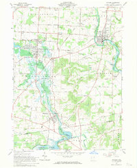
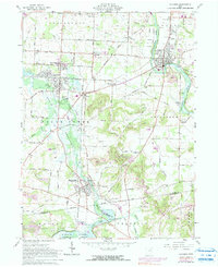
1961 Map of Navarre
USGS Topo · Published 1970About this map
The Tuscarawas River valley in the early 1960s was a landscape defined by industrial extraction and significant water management. Extensive Strip Mine operations and a Quarry dot the hillsides of Bethlehem and Franklin townships, contrasting with the engineered basin of the Sugar Creek Reservoir. Small settlements like Justus, Harmon, and Elton cluster along the rail corridors of the New York Chicago and St Louis and Baltimore and Ohio railroads. For genealogists, the map is particularly detailed, identifying numerous burial grounds such as Slutz Cem and Dietrick Cem. The presence of the Ames Airport and Canton Waterworks south of Navarre underscores the region's mid-century utility and transportation infrastructure.
Find a feature on this map
55 named features on this map. Tap any name to fly to it.
Don’t see what you’re looking for? This feature index may not catch every label — zoom into the map to look around manually.
Map Details
Editions of this 1961 Navarre Map
5 editions found
Other maps of this area

1901 · Massillon
USGS Topo · 1:62,500

1901 · Canton
USGS Topo · 1:62,500

1903 · Massillon
USGS Topo · 1:62,500

1903 · Canton
USGS Topo · 1:62,500

1912 · Dover
USGS Topo · 1:62,500

1914 · Navarre
USGS Topo · 1:62,500

1944 · Navarre
USGS Topo · 1:62,500

1944 · Dover
USGS Topo · 1:62,500

1951 · Canton
USGS Topo · 1:250,000

1951 · Bolivar
USGS Topo · 1:24,000