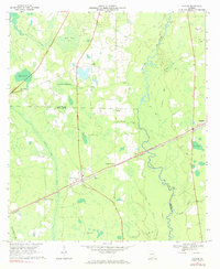
1968 Map of Naylor
USGS Topo · Published 1984About this map
The Alapaha River meanders through the heart of the coastal plain in this late-1960s survey, marking a distinct boundary between the wilder swampy lowlands and the developing agricultural and rail corridors of Lowndes and Lanier Counties. The rail-oriented development of the era is evident as the Seaboard Coast Line connects small hubs like Naylor and Stockton, while an Old Railroad Grade north of Dizon indicates a landscape in transition. Deeply tied to the land, numerous bays such as Friars Bay and Grand Bay dominate the drainage patterns, often punctuated by family-named landmarks and rural congregations. Genealogists may find value in the specific locations of several country churches and cemeteries, including St Marys Ch and Foreman Cem, which served these dispersed communities before modern highway expansion further altered the local geography.
Find a feature on this map
36 named features on this map. Tap any name to fly to it.
Don’t see what you’re looking for? This feature index may not catch every label — zoom into the map to look around manually.
Map Details
Editions of this 1968 Naylor Map
3 editions found
Other maps of this area

1953 · Waycross
USGS Topo · 1:250,000

1954 · Valdosta
USGS Topo · 1:250,000

1958 · Valdosta
USGS Topo · 1:250,000

1958 · Waycross
USGS Topo · 1:250,000

1959 · Valdosta
USGS Topo · 1:250,000

1968 · Naylor
USGS Topo · 1:24,000

1968 · Lakeland
USGS Topo · 1:24,000

1971 · Indianola
USGS Topo · 1:24,000

1971 · Howell
USGS Topo · 1:24,000

1971 · Stockton
USGS Topo · 1:24,000