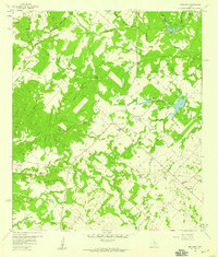
1958 Map of Nechanitz
USGS Topo · Published 1959About this map
Nechanitz and Waldeck sit at the center of this rural Fayette County landscape, where the agricultural patterns of the late 1950s are meticulously documented. The terrain is defined by a dense network of watercourses, including Cummins Creek and Turkey Creek, which create a varied topography of creek bottoms and rises like Hellers Hill. Small-scale industry is present through scattered Gravel Pits, while the presence of a Pipeline cutting across the southern half of the quadrangle signals the infrastructure of the mid-century energy sector.
Find a feature on this map
29 named features on this map. Tap any name to fly to it.
Don’t see what you’re looking for? This feature index may not catch every label — zoom into the map to look around manually.
Map Details
Editions of this 1958 Nechanitz Map
2 editions found
Other maps of this area

1919 · Fayettsville
USGS Topo · 1:62,500

1919 · Giddings
USGS Topo · 1:62,500

1953 · Seguin
USGS Topo · 1:250,000

1954 · Austin
USGS Topo · 1:250,000

1956 · La Grange
USGS Topo · 1:62,500

1957 · La Grange East
USGS Topo · 1:24,000

1958 · La Grange West
USGS Topo · 1:24,000

1958 · Seguin
USGS Topo · 1:250,000

1958 · Ledbetter
USGS Topo · 1:24,000

1958 · Carmine
USGS Topo · 1:24,000