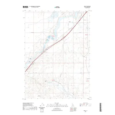
2020 Map of Neeley
USGS Topo · Published 2020About this map
The Snake River carves a deep path through Power County in this 2020 record, defining the local geography from the northern plains near Neeley to the prominent outcrops of Massacre Rocks. This landscape is marked by the complex intersection of high-desert terrain and human infrastructure, where irrigation features like the US Ditch and Main W Canal support the agricultural flats of Rockland Valley. The map details significant riverine features including Beaver Island and Goat Island, while the presence of the Ruts Trail and Rest Area Trail near the riverbanks points to a long history of travel through this corridor. To the south, the terrain rises toward Little Table Mtn, framed by the drainage of Rock Cr and its various forks. For those tracing local heritage, the Neeley Cemetery and family-named routes like Permann Ln and Roper Ln provide specific points of interest within the broader survey of the Snake River Plain.
Find a feature on this map
46 named features on this map. Tap any name to fly to it.
Don’t see what you’re looking for? This feature index may not catch every label — zoom into the map to look around manually.
Map Details
Editions of this 2020 Neeley Map
This is the sole edition of this map. No revisions or reprints were ever made.
Other maps of this area

1934 · American Falls
USGS Topo · 1:62,500

1934 · Rockland
USGS Topo · 1:62,500

1936 · American Falls
USGS Topo · 1:62,500

1937 · Rockland
USGS Topo · 1:62,500

1954 · Pocatello
USGS Topo · 1:250,000

1958 · Pocatello
USGS Topo · 1:250,000

1959 · Yale
USGS Topo · 1:62,500

1971 · Rockland East
USGS Topo · 1:24,000
1971 · Indian Springs
USGS Topo · 1:24,000
1971 · American Falls SW
USGS Topo · 1:24,000