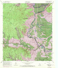
1954 Map of Negreet SW
USGS Topo · Published 1970About this map
The Sabine River serves as the central artery and state boundary in this detailed study of the borderlands between Texas and Louisiana. Recorded before and during the major inundation of the Toledo Bend Reservoir, the map reveals a landscape defined by oxbow lakes, sloughs, and family-named landmarks like Harpers Bend and Ferry Lake. The western portion is dominated by the Sabine National Forest, where the Sabine Lookout Tower stood watch over a network of creek branches and timbered ridges such as Moss Hill. Social and industrial history is visible in the presence of Oak Hill Church and the Lows Cemetery, while a dismantled railroad and various pipelines suggest the era's evolving transportation and energy infrastructure. The transition from free-flowing river bottom to a massive reservoir is captured here, showing how the rising waters began to alter the geography of Sabine County and Sabine Parish.
Find a feature on this map
40 named features on this map. Tap any name to fly to it.
Don’t see what you’re looking for? This feature index may not catch every label — zoom into the map to look around manually.
Map Details
Editions of this 1954 Negreet SW Map
3 editions found
Other maps of this area

1944 · Negreet
USGS Topo · 1:62,500

1944 · Wiergate
USGS Topo · 1:62,500

1948 · Wiergate
USGS Topo · 1:62,500

1953 · Alexandria
USGS Topo · 1:250,000

1954 · Toro
USGS Topo · 1:24,000

1954 · Columbus
USGS Topo · 1:24,000

1954 · Fairdale
USGS Topo · 1:24,000
1954 · Negreet
USGS Topo · 1:24,000

1954 · Negreet
USGS Topo · 1:62,500

1954 · Wiergate
USGS Topo · 1:62,500