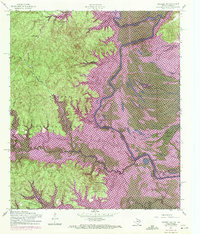
1954 Map of Negreet SW
USGS Topo · Published 1972About this map
The Sabine River forms the central spine of this landscape, acting as the border between Louisiana and Texas as it winds through a dense network of wetlands and bayous. In the 1950s and 1960s, this region underwent a significant transformation with the creation of the Toledo Bend Reservoir, which altered the drainage of local waterways like Hurricane Bayou and Sixmile Bayou. The Texas side is dominated by the Sabine National Forest, where the Sabine Lookout Tower stands as a sentinel over the timberlands.
Find a feature on this map
35 named features on this map. Tap any name to fly to it.
Don’t see what you’re looking for? This feature index may not catch every label — zoom into the map to look around manually.
Map Details
Editions of this 1954 Negreet SW Map
3 editions found
Other maps of this area

1944 · Negreet
USGS Topo · 1:62,500

1944 · Wiergate
USGS Topo · 1:62,500

1948 · Wiergate
USGS Topo · 1:62,500

1953 · Alexandria
USGS Topo · 1:250,000

1954 · Toro
USGS Topo · 1:24,000

1954 · Columbus
USGS Topo · 1:24,000

1954 · Fairdale
USGS Topo · 1:24,000
1954 · Negreet
USGS Topo · 1:24,000

1954 · Negreet
USGS Topo · 1:62,500

1954 · Wiergate
USGS Topo · 1:62,500