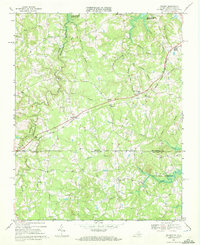
1968 Map of Nelson
USGS Topo · Published 1972About this map
Nelson and Buffalo Junction serve as the primary rail-connected hubs in this 1968 landscape, situated along the Norfolk and Franklin line. The map captures a moment of topographical transition, where rural crossroads like Siddon, Perkins, and Averett are dotted with numerous unnamed family Cem sites, suggesting a deeply rooted local genealogy. The northern and eastern sections are defined by the rising waters of the John H Kerr Reservoir, which reaches into the valleys of Buffalo Creek and Aarons Creek. This hydrology, combined with the presence of Wharton Memorial Ch and Hebron Ch, reflects a community structured around its watercourses and small country congregations. To the south, across the state line into North Carolina, the terrain remains heavily dissected by Johnson Creek and Grassy Creek, preserving a network of unimproved roads and farm boundaries in Granville Co.
Find a feature on this map
35 named features on this map. Tap any name to fly to it.
Don’t see what you’re looking for? This feature index may not catch every label — zoom into the map to look around manually.
Map Details
Editions of this 1968 Nelson Map
3 editions found
Other maps of this area

1941 · Clarksville
USGS Topo · 1:48,000

1943 · Clarksville
USGS Topo · 1:62,500

1943 · Roxboro
USGS Topo · 1:62,500

1953 · Oxford
USGS Topo · 1:62,500

1953 · South Boston
USGS Topo · 1:62,500

1953 · Greensboro
USGS Topo · 1:250,000

1954 · Greensboro
USGS Topo · 1:250,000

1957 · South Boston
USGS Topo · 1:62,500

1957 · Clarksville
USGS Topo · 1:62,500

1962 · Greensboro
USGS Topo · 1:250,000