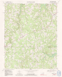
1968 Map of Nelson
USGS Topo · Published 1991About this map
The Virginia North Carolina state line bisects this landscape, marking a rural borderland where Halifax and Mecklenburg counties meet. This terrain is defined by the winding course of Aarons Creek, which serves as a natural boundary before reaching the northern reaches of the John H Kerr Reservoir. The late 1960s settlement pattern reflects a deeply rooted community of country churches and small crossings, including Wharton Memorial Ch, Hebron Ch, and the crossroads at Siddon.
Find a feature on this map
41 named features on this map. Tap any name to fly to it.
Don’t see what you’re looking for? This feature index may not catch every label — zoom into the map to look around manually.
Map Details
Editions of this 1968 Nelson Map
3 editions found
Other maps of this area

1941 · Clarksville
USGS Topo · 1:48,000

1943 · Clarksville
USGS Topo · 1:62,500

1943 · Roxboro
USGS Topo · 1:62,500

1953 · Oxford
USGS Topo · 1:62,500

1953 · South Boston
USGS Topo · 1:62,500

1953 · Greensboro
USGS Topo · 1:250,000

1954 · Greensboro
USGS Topo · 1:250,000

1957 · South Boston
USGS Topo · 1:62,500

1957 · Clarksville
USGS Topo · 1:62,500

1962 · Greensboro
USGS Topo · 1:250,000