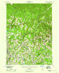
1942 Map of Neversink
USGS Topo · Published 1959About this map
The Neversink River carves a deep valley through the heart of the Catskill region, serving as the primary geographic corridor for settlements like Grahamsville and Hasbrouck. Compiled in 1942, this survey shows the landscape before the construction of the Neversink Reservoir, capturing the original course of the river and the hamlets that relied upon it. In the southwest, Liberty stands as a significant regional hub, connected to Ferndale by the Nyo And W RR. The map detail is particularly strong along the northern reaches, where the Hardenburg Mongaup Mt and Denning uplands are dotted with isolated ponds such as Mongaup Pond and Hodge Pond. This era reflects a transition where traditional farming and mountain hamlets like Willowemoc and Claryville coexisted with the growing vacation economy around Loch Sheldrake.
Find a feature on this map
52 named features on this map. Tap any name to fly to it.
Don’t see what you’re looking for? This feature index may not catch every label — zoom into the map to look around manually.
Map Details
Editions of this 1942 Neversink Map
2 editions found

Other maps of this area

1900 · Phoenicia
USGS Topo · 1:62,500

1901 · Margaretville
USGS Topo · 1:62,500

1903 · Phoenicia
USGS Topo · 1:62,500

1903 · Slide Mountain
USGS Topo · 1:62,500

1904 · Margaretville
USGS Topo · 1:62,500

1904 · Ellenville
USGS Topo · 1:62,500

1905 · Slide Mountain
USGS Topo · 1:62,500

1906 · Ellenville
USGS Topo · 1:62,500

1909 · Monticello
USGS Topo · 1:62,500

1910 · Neversink
USGS Topo · 1:62,500