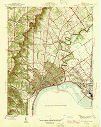
1946 Map of New Albany
USGS Topo · Published 1946About this map
The Ohio River waterfront serves as the industrial and transit anchor for this post-war landscape, where the Falls of the Ohio dictates the river's navigation. The urban grid of New Albany is densely detailed, showing the Court House, City Hall, and St Edwards Hospital as established community fixtures. Further inland, the terrain rises sharply toward Bald Knob and Floyds Knobs, marking a transition from the river valley to the elevated knobs. The Clark Military Reservation dominates the northeastern corner, while smaller rural nodes like Jacobs and St Marys Ch remain connected by the historic Indianapolis Road and Chicago Road. Significant early industrial markers, such as Blackiston Mill on Silver Creek, reflect the region's reliance on water power and rail networks, including the Southern and Pennsylvania lines.
Find a feature on this map
62 named features on this map. Tap any name to fly to it.
Don’t see what you’re looking for? This feature index may not catch every label — zoom into the map to look around manually.
Map Details
Editions of this 1946 New Albany Map
2 editions found

Other maps of this area

1905 · Prospect
USGS Topo · 1:62,500

1907 · Louisville
USGS Topo · 1:62,500

1909 · Kosmosdale
USGS Topo · 1:48,000

1912 · Prospect
USGS Topo · 1:62,500

1912 · Kosmosdale
USGS Topo · 1:62,500

1937 · Jeffersonville
USGS Topo · 1:24,000

1937 · Charlestown
USGS Topo · 1:24,000

1938 · Speed
USGS Topo · 1:24,000

1939 · New Albany
USGS Topo · 1:24,000

1939 · Georgetown
USGS Topo · 1:24,000