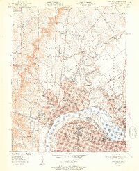
1951 Map of New Albany
USGS Topo · Published 1951About this map
The Ohio River corridor at the midpoint of the twentieth century reveals a dense network of industrial and civic life connecting New Albany and Louisville. This era is defined by the heavy infrastructure of the Falls of the Ohio, where Dam No 41 and the George Rogers Clark Memorial Bridge anchor the river traffic. On the Indiana side, the transition from urban centers like Clarksville and Jeffersonville to the surrounding heights is marked by significant institutions, including the Silvercrest State Hospital and the County Infirmary.
Find a feature on this map
95 named features on this map. Tap any name to fly to it.
Don’t see what you’re looking for? This feature index may not catch every label — zoom into the map to look around manually.
Map Details
Editions of this 1951 New Albany Map
2 editions found
Other maps of this area

1905 · Prospect
USGS Topo · 1:62,500

1907 · Louisville
USGS Topo · 1:62,500

1909 · Kosmosdale
USGS Topo · 1:48,000

1912 · Prospect
USGS Topo · 1:62,500

1912 · Kosmosdale
USGS Topo · 1:62,500

1937 · Jeffersonville
USGS Topo · 1:24,000

1937 · Charlestown
USGS Topo · 1:24,000

1938 · Speed
USGS Topo · 1:24,000

1939 · New Albany
USGS Topo · 1:24,000

1939 · Georgetown
USGS Topo · 1:24,000