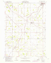
1960 Map of New Bavaria
USGS Topo · Published 1974About this map
Holgate and New Bavaria anchor this landscape of the Black Swamp region, where the grid of the Public Land Survey System is superimposed over a network of vital drainage infrastructure. Numerous watercourses like North Creek and Powell Creek are supplemented by man-made cuts including Gustwiller Ditch and Mess Ditch, illustrating the intensive efforts required to maintain productive farmland in this corner of northwest Ohio. The Norfolk and Western railway cuts diagonally through the southern townships, passing the small settlement of Wisterman. Local community life is centered around rural landmarks like St Stephens Ch and the Sacred Heart Sch, while the presence of several burying grounds such as St Johns Cem and Township Cem provide significant points of interest for those researching the early families of Pleasant and Monroe townships.
Find a feature on this map
36 named features on this map. Tap any name to fly to it.
Don’t see what you’re looking for? This feature index may not catch every label — zoom into the map to look around manually.
Map Details
Editions of this 1960 New Bavaria Map
3 editions found
Other maps of this area

1907 · Defiance
USGS Topo · 1:62,500

1908 · Ottawa
USGS Topo · 1:62,500

1908 · Napoleon
USGS Topo · 1:62,500

1909 · Defiance
USGS Topo · 1:62,500

1909 · Continental
USGS Topo · 1:62,500

1953 · Fort Wayne
USGS Topo · 1:250,000

1956 · Fort Wayne
USGS Topo · 1:250,000

1959 · Defiance East
USGS Topo · 1:24,000

1959 · Florida
USGS Topo · 1:24,000

1960 · Ottawa
USGS Topo · 1:24,000