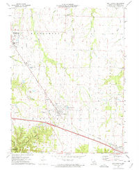
1973 Map of New Florence
USGS Topo · Published 1975About this map
New Florence serves as a central hub on this Missouri landscape, situated where the Norfolk and Western railroad tracks cut across the terrain. The map captures a transition between the organized grids of settlements like Montgomery City and the more varied topography of the Danville State Wildlife Area. This region is defined by its industrial and agricultural markers, with numerous claypits and a Quarry scattered throughout, particularly near Calhoun Hollow. Local history is preserved in the locations of the New Florence Cem and Mt Pleasant Cem, while the Fairground near the edge of Montgomery City points to the community's social gathering places. Waterways such as Wolf Creek and Bear Creek drain the surrounding fields, illustrating the natural drainage patterns that shaped early land use and settlement placement before the modern development of local infrastructure like the R-II Sch.
Find a feature on this map
31 named features on this map. Tap any name to fly to it.
Don’t see what you’re looking for? This feature index may not catch every label — zoom into the map to look around manually.
Map Details
Editions of this 1973 New Florence Map
This is the sole edition of this map. No revisions or reprints were ever made.
Other maps of this area

1890 · Louisiana
USGS Topo · 1:125,000

1890 · Mexico
USGS Topo · 1:125,000

1890 · Hermann
USGS Topo · 1:125,000

1890 · Fulton
USGS Topo · 1:125,000

1940 · Montgomery City
USGS Topo · 1:62,500

1942 · Montgomery City
USGS Topo · 1:62,500

1942 · Wellsville
USGS Topo · 1:62,500

1942 · New Florence
USGS Topo · 1:62,500

1942 · Bellflower
USGS Topo · 1:62,500

1945 · Bellflower
USGS Topo · 1:62,500