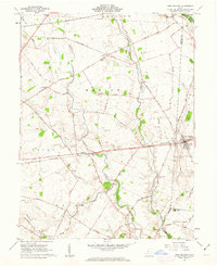
1961 Map of New Holland
USGS Topo · Published 1963About this map
North Fork Paint Creek and its many tributaries, including Compton Creek and Glaze Run, carve through this section of the Virginia Military District in the early 1960s. The village of New Holland serves as a local hub at the junction of the Pennsylvania railroad and several arterial roads, while smaller clusters like Manara and Johnson dot the landscape. This era shows a community defined by its agricultural layout, marked by numerous rural burial grounds such as Lloyd Cem and the Rowe Cem situated near the winding Indian Camp Run.
Find a feature on this map
57 named features on this map. Tap any name to fly to it.
Don’t see what you’re looking for? This feature index may not catch every label — zoom into the map to look around manually.
Map Details
Editions of this 1961 New Holland Map
Other maps of this area

1906 · Mt Sterling
USGS Topo · 1:62,500

1911 · Era
USGS Topo · 1:62,500

1912 · Roxabell
USGS Topo · 1:62,500

1913 · Era
USGS Topo · 1:62,500

1914 · Roxabell
USGS Topo · 1:62,500

1917 · Greenfield
USGS Topo · 1:62,500

1943 · Era
USGS Topo · 1:62,500

1944 · Greenfield
USGS Topo · 1:62,500

1944 · Roxabell
USGS Topo · 1:62,500

1947 · Columbus
USGS Topo · 1:250,000