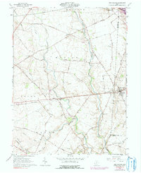
1961 Map of New Holland
USGS Topo · Published 1991About this map
The North Fork Paint Creek and its many tributaries, including Compton Creek and Turkey Run, define the rolling agricultural landscape of this region during the early 1960s. The area is a mosaic of small family farmsteads and rural crossroads, with the village of New Holland serving as a focal point where the Penn Central rail line cuts across the terrain. Smaller hamlets like Pancoastburg and Manara dot the northern reaches, while the southeastern corner reveals the small settlement of Dogtown.
Find a feature on this map
58 named features on this map. Tap any name to fly to it.
Don’t see what you’re looking for? This feature index may not catch every label — zoom into the map to look around manually.
Map Details
Editions of this 1961 New Holland Map
Other maps of this area

1906 · Mt Sterling
USGS Topo · 1:62,500

1911 · Era
USGS Topo · 1:62,500

1912 · Roxabell
USGS Topo · 1:62,500

1913 · Era
USGS Topo · 1:62,500

1914 · Roxabell
USGS Topo · 1:62,500

1917 · Greenfield
USGS Topo · 1:62,500

1943 · Era
USGS Topo · 1:62,500

1944 · Greenfield
USGS Topo · 1:62,500

1944 · Roxabell
USGS Topo · 1:62,500

1947 · Columbus
USGS Topo · 1:250,000