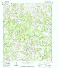
1965 Map of New Hope
USGS Topo · Published 1987About this map
The New Hope Oil Field dominates this mid-1960s landscape, illustrating the industrial footprint of petroleum extraction in East Texas. The infrastructure of the era is clearly marked, featuring a refinery, pumping stations, and a network of pipelines that cut across the local topography. This industrial activity exists alongside established rural communities, where social life centered on locations like Macon Ch and the South Franklin CSD No 28 Sch.
Find a feature on this map
33 named features on this map. Tap any name to fly to it.
Don’t see what you’re looking for? This feature index may not catch every label — zoom into the map to look around manually.
Map Details
Editions of this 1965 New Hope Map
2 editions found
Other maps of this area

1953 · Texarkana
USGS Topo · 1:250,000

1956 · Texarkana
USGS Topo · 1:250,000

1956 · Tyler
USGS Topo · 1:250,000

1960 · Winnsboro
USGS Topo · 1:24,000

1960 · Newsome
USGS Topo · 1:24,000

1960 · Leesburg
USGS Topo · 1:24,000

1964 · Mount Vernon
USGS Topo · 1:24,000

1964 · Saltillo
USGS Topo · 1:24,000

1964 · Purley
USGS Topo · 1:24,000

1965 · Winfield
USGS Topo · 1:24,000