
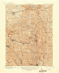
1911 Map of New Lexington
USGS Topo · Published 1939About this map
New Lexington serves as the focal point of this pre-WWI landscape, situated at the junction of the Zanesville and Western RR and the Toledo and Ohio Central RR. The region is defined by a dense network of coal-mining settlements and rural schools that speak to the industrial and social character of early 20th-century Ohio. Notable landmarks such as the St Aloysius Academy and the County Infirmary reflect the civic infrastructure of the era, while the deep valleys of Sunday Creek and Monday Creek dictate the settlement patterns of towns like Shawnee and Corning. The prevalence of small, named schools—including Blossom Grove School, Violetta School, and Dogan School—illustrates the localized nature of rural education before the consolidation of the mid-century. This survey captures a moment of peak activity for the local rail-and-mine economy across the Perry, Morgan, and Athens county lines.
Find a feature on this map
109 named features on this map. Tap any name to fly to it.
Don’t see what you’re looking for? This feature index may not catch every label — zoom into the map to look around manually.
Map Details
Editions of this 1911 New Lexington Map
2 editions found
Other maps of this area

1903 · Athens
USGS Topo · 1:62,500

1904 · Zaleski
USGS Topo · 1:62,500

1904 · Chesterhill
USGS Topo · 1:62,500

1905 · Athens
USGS Topo · 1:62,500

1906 · Chesterhill
USGS Topo · 1:62,500

1907 · Zaleski
USGS Topo · 1:62,500

1907 · Logan
USGS Topo · 1:62,500

1909 · Thornville
USGS Topo · 1:62,500

1909 · Logan
USGS Topo · 1:62,500

1910 · Philo
USGS Topo · 1:62,500