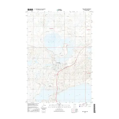
2016 Map of New London
USGS Topo · Published 2016About this map
The Middle Fork Crow River flows through the heart of New London, a landscape defined by an intricate network of glacial lakes and wetlands in Kandiyohi County. This modern survey illustrates the town's orientation around the Mill Pond and the expansive Lake Monongalia to the north. Local history and genealogy are anchored by several notable sites, including the Lebanon Cem near the riverbanks and the Lady of the Lake Cem situated further south near Nest Lake. The map reveals how the modern road network, including the Highway 23 Frontage Rd NE, has integrated with older routes like Old Mill Rd, while the surrounding terrain features prominent elevations such as Oak Hill. The abundance of water bodies, from the large Green Lake to smaller basins like Shoemaker Lake and Twenty Lake, reflects the characteristic "Land of 10,000 Lakes" topography in this portion of central Minnesota.
Find a feature on this map
74 named features on this map. Tap any name to fly to it.
Don’t see what you’re looking for? This feature index may not catch every label — zoom into the map to look around manually.
Map Details
Editions of this 2016 New London Map
This is the sole edition of this map. No revisions or reprints were ever made.
Other maps of this area

1953 · Saint Cloud
USGS Topo · 1:250,000

1956 · Atwater
USGS Topo · 1:62,500

1957 · Saint Cloud
USGS Topo · 1:250,000

1958 · Saint Cloud
USGS Topo · 1:250,000

1958 · Solomon Lake
USGS Topo · 1:24,000

1967 · Mount Tom
USGS Topo · 1:24,000

1967 · Belgrade
USGS Topo · 1:24,000
1967 · Georgeville
USGS Topo · 1:24,000

1967 · Hawick
USGS Topo · 1:24,000
1967 · Lake Henry
USGS Topo · 1:24,000