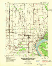
1954 Map of New Madrid
USGS Topo · Published 1955About this map
Mississippi River hydraulics and the complex drainage of the Little River basin dominate this mid-century survey of the Bootheel region. The landscape is defined by the sharp transition between the elevated terrain of Sikes Ridge and the intensive engineering of the lowlands, where a dense network including Main Ditch No 41 and Ditch No 46 speaks to the massive land reclamation efforts of the era. The cultural landscape shows a distinct pattern of small, segregated rural centers, including the Rosenwald School and St Mary School, serving scattered agricultural communities.
Find a feature on this map
110 named features on this map. Tap any name to fly to it.
Don’t see what you’re looking for? This feature index may not catch every label — zoom into the map to look around manually.
Map Details
Editions of this 1954 New Madrid Map
2 editions found

Other maps of this area

1925 · Reelfoot Lake
USGS Topo · 1:62,500

1931 · Sikeston
USGS Topo · 1:62,500

1934 · Bloomfield
USGS Topo · 1:62,500

1934 · Sikeston
USGS Topo · 1:62,500

1939 · Bloomfield
USGS Topo · 1:62,500

1939 · Sikeston
USGS Topo · 1:62,500

1939 · Reelfoot Lake
USGS Topo · 1:62,500

1939 · Charleston
USGS Topo · 1:62,500

1939 · Portageville
USGS Topo · 1:62,500

1939 · New Madrid
USGS Topo · 1:62,500