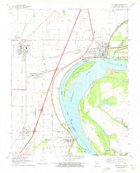
1971 Map of New Madrid
USGS Topo · Published 1973About this map
The Mississippi River creates a dramatic sweeping bend on this 1971 survey, defining the border between Missouri and Kentucky. Along its banks, the town of New Madrid is detailed alongside industrial and transport infrastructure, including the St Louis Southwestern and St Louis - San Francisco railroads. The landscape is heavily marked by flood control measures like the Levee and Mud Ditch, reflecting the hydrologic challenges of the Bootheel region.
Find a feature on this map
62 named features on this map. Tap any name to fly to it.
Don’t see what you’re looking for? This feature index may not catch every label — zoom into the map to look around manually.
Map Details
Editions of this 1971 New Madrid Map
2 editions found
Other maps of this area

1925 · Reelfoot Lake
USGS Topo · 1:62,500

1939 · Reelfoot Lake
USGS Topo · 1:62,500

1939 · Portageville
USGS Topo · 1:62,500

1939 · New Madrid
USGS Topo · 1:62,500

1939 · Bayouville
USGS Topo · 1:62,500

1951 · New Madrid SE
USGS Topo · 1:24,000

1951 · Hubbard Lake
USGS Topo · 1:24,000

1954 · New Madrid
USGS Topo · 1:62,500

1955 · Portageville
USGS Topo · 1:62,500

1955 · Bayouville
USGS Topo · 1:62,500