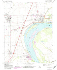
1971 Map of New Madrid
USGS Topo · Published 1983About this map
New Madrid anchors this riverfront landscape at a critical bend in the Mississippi River, where the town's grid meets the shifting channels of Morrison Chute and Morrison Towhead. The map reveals a complex interface between agricultural lowlands and the river’s hydrological influence, evidenced by the extensive levee systems and drainage features like St Johns Bayou. This 1970s-era documentation, updated with photorevisions in the early 1980s, captures the region's deep historical layers through numerous family and community cemeteries, including St Marys Cem, Dawson Cem, and Mounds Cem. The transportation network is defined by the St Louis Southwestern railroad and the expansion of modern highways, illustrated by Interchange 44 and Interchange 40 near Marston. Cultural landmarks such as a State Historic Site and an Indian Mound reflect the long-standing human presence in this flood-prone Missouri Bootheel region.
Find a feature on this map
59 named features on this map. Tap any name to fly to it.
Don’t see what you’re looking for? This feature index may not catch every label — zoom into the map to look around manually.
Map Details
Editions of this 1971 New Madrid Map
2 editions found
Other maps of this area

1925 · Reelfoot Lake
USGS Topo · 1:62,500

1939 · Reelfoot Lake
USGS Topo · 1:62,500

1939 · Portageville
USGS Topo · 1:62,500

1939 · New Madrid
USGS Topo · 1:62,500

1939 · Bayouville
USGS Topo · 1:62,500

1951 · New Madrid SE
USGS Topo · 1:24,000

1951 · Hubbard Lake
USGS Topo · 1:24,000

1954 · New Madrid
USGS Topo · 1:62,500

1955 · Portageville
USGS Topo · 1:62,500

1955 · Bayouville
USGS Topo · 1:62,500