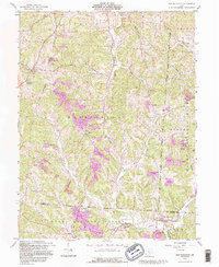
1992 Map of New Plymouth
USGS Topo · Published 1995About this map
Wayne National Forest dominates the southern landscape of this Hocking and Vinton County borderland, where the terrain is heavily marked by industrial activity. Extensive Strip Mine and Reclaimed Strip Mine operations are concentrated throughout the hills, particularly around Ilesboro and Starr. These excavations, often following the contours of Marble Ridge and Calico Ridge, reveal the region's reliance on mineral extraction during the late 20th century.
Find a feature on this map
37 named features on this map. Tap any name to fly to it.
Don’t see what you’re looking for? This feature index may not catch every label — zoom into the map to look around manually.
Map Details
Editions of this 1992 New Plymouth Map
This is the sole edition of this map. No revisions or reprints were ever made.
Other maps of this area

1904 · Zaleski
USGS Topo · 1:62,500

1907 · Zaleski
USGS Topo · 1:62,500

1907 · Logan
USGS Topo · 1:62,500

1907 · Lancaster
USGS Topo · 1:62,500

1909 · Lancaster
USGS Topo · 1:62,500

1909 · Logan
USGS Topo · 1:62,500

1910 · Laurelville
USGS Topo · 1:62,500

1912 · Laurelville
USGS Topo · 1:62,500

1944 · Laurelville
USGS Topo · 1:62,500

1947 · Columbus
USGS Topo · 1:250,000