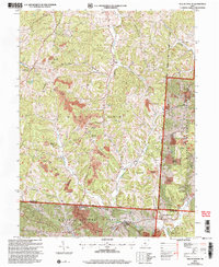
2002 Map of New Plymouth
USGS Topo · Published 2006About this map
Wayne National Forest lands dominate this Hocking County landscape, revealing a region defined by industrial extraction and subsequent environmental recovery. Extensive reclaimed strip mines and active strip mines are etched across the ridges and hollows, particularly around Ilesboro and Metz. These marks of heavy industry contrast with the numerous country burial grounds and small congregations that anchor the local genealogy.
Find a feature on this map
51 named features on this map. Tap any name to fly to it.
Don’t see what you’re looking for? This feature index may not catch every label — zoom into the map to look around manually.
Map Details
Editions of this 2002 New Plymouth Map
This is the sole edition of this map. No revisions or reprints were ever made.
Other maps of this area

1904 · Zaleski
USGS Topo · 1:62,500

1907 · Zaleski
USGS Topo · 1:62,500

1907 · Logan
USGS Topo · 1:62,500

1907 · Lancaster
USGS Topo · 1:62,500

1909 · Lancaster
USGS Topo · 1:62,500

1909 · Logan
USGS Topo · 1:62,500

1910 · Laurelville
USGS Topo · 1:62,500

1912 · Laurelville
USGS Topo · 1:62,500

1944 · Laurelville
USGS Topo · 1:62,500

1947 · Columbus
USGS Topo · 1:250,000