1978 Map of New Smyrna Beach
USGS Topo · Published 1980About this map
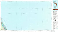
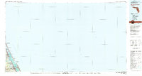
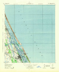
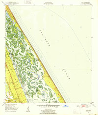
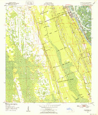
The Halifax River and the Intracoastal Waterway define the coastal geography of the Volusia County shoreline in the late 1970s. This survey, compiled from 1970 source material and updated with 1977 aerial photography, captures the dense string of Atlantic settlements including Port Orange, Daytona Beach Shores, and Wilbur-by-the-Sea. The map illustrates the crucial maritime corridor at Ponce de Leon Inlet, guarded by a U.S. Coast Guard Reservation. Inland development is anchored by the New Smyrna Beach Municipal Airport and smaller residential hubs like Mission City and Glencoe, showing the post-war suburban expansion along the Florida coast.
Find a feature on this map
22 named features on this map. Tap any name to fly to it.
Don’t see what you’re looking for? This feature index may not catch every label — zoom into the map to look around manually.
Map Details
Editions of this 1978 New Smyrna Beach Map
2 editions found
Other maps of this area

1927 · Matanzas
USGS Topo · 1:48,000

1937 · Port Orange
USGS Topo · 1:48,000

1937 · Ormond
USGS Topo · 1:48,000

1943 · Matanzas
USGS Topo · 1:62,500

1943 · Port Orange
USGS Topo · 1:62,500

1944 · Ormond
USGS Topo · 1:62,500

1944 · Matanzas
USGS Topo · 1:62,500
1944 · Port Orange
USGS Topo · 1:62,500
1950 · Ariel
USGS Topo · 1:24,000
1950 · Edgewater
USGS Topo · 1:24,000