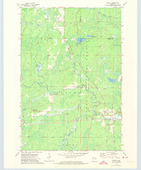
1972 Map of Newald
USGS Topo · Published 1974About this map
The timbered highlands of the Nicolet National Forest dominate this early 1970s survey, where the convergence of the Chicago and North Western and Soo Line railroads defined the local economy and geography. The small settlement of Newald sits in the northern reaches, while the village of Cavour and the rail interchange at Laona Junction serve as southern anchors for the region. The landscape is a complex of wetlands and waterways, including the winding Peshtigo River and several glacial features like Van Zile Lake and Marsh No 10. Higher elevations are marked by the Consolidated Lookout Tower, a critical vantage point for forest management. This map illustrates the intersection of industrial rail transport and protected wilderness, capturing the character of northern Wisconsin's timber country at a time when fire towers and rail sidings were still essential features of the rural infrastructure.
Find a feature on this map
30 named features on this map. Tap any name to fly to it.
Don’t see what you’re looking for? This feature index may not catch every label — zoom into the map to look around manually.
Map Details
Editions of this 1972 Newald Map
2 editions found
Other maps of this area

1938 · Alvin
USGS Topo · 1:48,000

1939 · Crandon
USGS Topo · 1:48,000

1939 · Laona
USGS Topo · 1:48,000

1939 · Long Lake
USGS Topo · 1:48,000

1941 · Crandon
USGS Topo · 1:48,000

1946 · Laona
USGS Topo · 1:48,000

1946 · Alvin
USGS Topo · 1:48,000

1947 · Crandon
USGS Topo · 1:48,000

1948 · Long Lake
USGS Topo · 1:48,000

1954 · Iron Mountain
USGS Topo · 1:250,000