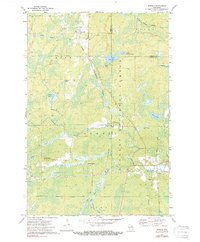
1972 Map of Newald
USGS Topo · Published 1991About this map
The Chicago and North Western and Soo Line railroads intersect at Laona Junction, forming a vital transportation hub in this heavily forested section of Wisconsin. This 1972 survey, later photoinspected in the early 1980s, documents the Northwoods landscape where the Nicolet National Forest spans the Forest and Florence County line. The terrain is defined by a complex drainage system, including the Peshtigo River and the South Branch Popple River, alongside several wetland areas like Marsh No 10. Human settlement is concentrated in small centers like Newald and Cavour, while the Consolidated Lookout Tower stands as a sentinel over the timberland. Local infrastructure is sparse, characterized by several Gravel Pits and the family-named Gruman Road, reflecting the area's historical reliance on forestry and natural resource management.
Find a feature on this map
27 named features on this map. Tap any name to fly to it.
Don’t see what you’re looking for? This feature index may not catch every label — zoom into the map to look around manually.
Map Details
Editions of this 1972 Newald Map
2 editions found
Other maps of this area

1938 · Alvin
USGS Topo · 1:48,000

1939 · Crandon
USGS Topo · 1:48,000

1939 · Laona
USGS Topo · 1:48,000

1939 · Long Lake
USGS Topo · 1:48,000

1941 · Crandon
USGS Topo · 1:48,000

1946 · Laona
USGS Topo · 1:48,000

1946 · Alvin
USGS Topo · 1:48,000

1947 · Crandon
USGS Topo · 1:48,000

1948 · Long Lake
USGS Topo · 1:48,000

1954 · Iron Mountain
USGS Topo · 1:250,000