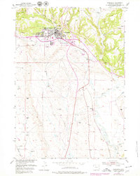
1951 Map of Newcastle
USGS Topo · Published 1979About this map
Newcastle serves as the focal point of this 1951 survey, situated at the confluence of several vital watercourses including Cambria Creek and Little Oil Creek. The map documents the city's mid-century footprint, featuring the Armory, the Greenwood Cem, and the Golf Course to the west. Revisions from 1979 illustrate the later addition of a Drive-in Theater and expanded Trailer Park areas, reflecting the region's post-war growth and changing local amenities.
Find a feature on this map
25 named features on this map. Tap any name to fly to it.
Don’t see what you’re looking for? This feature index may not catch every label — zoom into the map to look around manually.
Map Details
Editions of this 1951 Newcastle Map
3 editions found
Other maps of this area

1899 · Newcastle
USGS Topo · 1:125,000

1901 · Newcastle
USGS Topo · 1:125,000

1951 · Owens
USGS Topo · 1:24,000

1951 · Newcastle
USGS Topo · 1:24,000

1951 · Morrisey NE
USGS Topo · 1:24,000

1951 · Fanny Peak
USGS Topo · 1:24,000

1951 · Osage SE
USGS Topo · 1:24,000

1951 · Clifton
USGS Topo · 1:24,000

1955 · Newcastle
USGS Topo · 1:250,000

1958 · Newcastle
USGS Topo · 1:250,000