
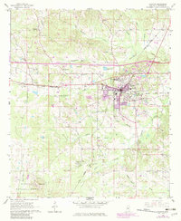
1966 Map of Newton
USGS Topo · Published 1967About this map
The railroad town of Newton serves as the focal point of this mid-1960s survey, situated at the busy junction of the Illinois Central and the Gulf Mobile and Ohio railroads. The town landscape is marked by Clark Memorial College, several water tanks, and a local Radio Tower (WBKN), while the nearby O'Keefe Airfield points to a growing postwar aviation presence. To the west, the village of Lawrence sits along the rail line, surrounded by a rural tapestry of timber and agriculture.
Find a feature on this map
42 named features on this map. Tap any name to fly to it.
Don’t see what you’re looking for? This feature index may not catch every label — zoom into the map to look around manually.
Map Details
Editions of this 1966 Newton Map
2 editions found
Other maps of this area

1921 · Forest
USGS Topo · 1:48,000

1922 · Forest
USGS Topo · 1:62,500

1950 · Forest
USGS Topo · 1:62,500

1952 · Forest
USGS Topo · 1:62,500

1953 · Meridian
USGS Topo · 1:250,000

1957 · Meridian
USGS Topo · 1:250,000

1965 · Meridian
USGS Topo · 1:250,000

1966 · Hickory
USGS Topo · 1:24,000

1966 · Decatur NW
USGS Topo · 1:24,000

1966 · Decatur
USGS Topo · 1:24,000