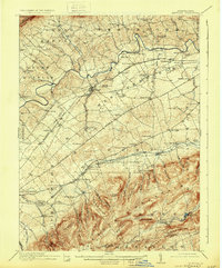
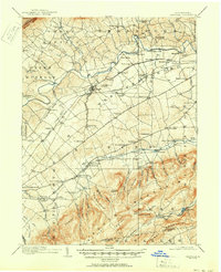
1919 Map of Newville
USGS Topo · Published 1931About this map
Conodoguinet Creek and Yellow Breeches Creek define the agrarian valley of central Cumberland County, showing a landscape tightly organized by late 19th-century rail and water infrastructure. The Cumberland Valley R. R. and Reading and Philadelphia R. R. cut across the territory, connecting rural hubs like Newville and Walnut Bottom to regional markets. Numerous small-scale industrial sites are visible, including Heiters Mill, Greiders Mill, and Elliotts Mill, illustrating how local water power remained vital to the community even as rail lines expanded.
Find a feature on this map
109 named features on this map. Tap any name to fly to it.
Don’t see what you’re looking for? This feature index may not catch every label — zoom into the map to look around manually.
Map Details
Editions of this 1919 Newville Map
6 editions found
Other maps of this area

1902 · Chambersburg
USGS Topo · 1:62,500

1904 · Carlisle
USGS Topo · 1:62,500

1907 · New Bloomfield
USGS Topo · 1:62,500

1908 · Gettysburg
USGS Topo · 1:62,500

1909 · Fairfield
USGS Topo · 1:62,500

1919 · Newville
USGS Topo · 1:62,500

1919 · Mattawana
USGS Topo · 1:62,500

1923 · Shippensburg
USGS Topo · 1:62,500

1930 · Loysville
USGS Topo · 1:62,500

1933 · Loysville
USGS Topo · 1:62,500
Featured Places
- Shippensburg, PA
- Dickinson, Penn Township
- Plainfield, West Pennsboro Township
- Southampton Township, PA
- North Newton Township, PA