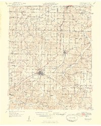
1948 Map of Niangua
USGS Topo · Published 1948About this map
Marshfield and the surrounding Webster County highlands are documented here during the late 1940s, a period when the Ozark plateau was still defined by a dense network of rural school districts and neighborhood churches. The San Francisco railroad line and U.S. 66 cut diagonally through the terrain, anchoring settlements like Niangua and Northview. Away from these primary corridors, the landscape is deeply etched by the Niangua River and its numerous tributaries, including the East Fork Niangua River and West Fork Niangua River. This survey captures the region's transition as the traditional river-and-road economy persisted, evidenced by named crossings such as Bumgarner Ford and the Hamilton Bridge. Genealogists will find a wealth of specific landmarks, from the Eighty Eight School to family-named sites like Marlin Cemetery and Forkners Hill, providing a clear view of the social geography before mid-century consolidations.
Find a feature on this map
89 named features on this map. Tap any name to fly to it.
Don’t see what you’re looking for? This feature index may not catch every label — zoom into the map to look around manually.
Map Details
Editions of this 1948 Niangua Map
2 editions found

Other maps of this area

1884 · Springfield
USGS Topo · 1:125,000

1884 · Bolivar
USGS Topo · 1:125,000

1886 · Springfield
USGS Topo · 1:125,000

1892 · Bolivar
USGS Topo · 1:125,000

1937 · Ozark
USGS Topo · 1:48,000

1939 · Fordland
USGS Topo · 1:62,500

1939 · Long Lane
USGS Topo · 1:62,500

1941 · Lebanon
USGS Topo · 1:62,500

1942 · Fordland
USGS Topo · 1:62,500

1942 · Long Lane
USGS Topo · 1:62,500