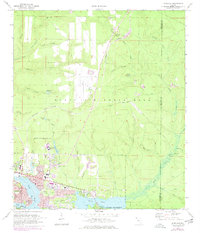
1970 Map of Niceville
USGS Topo · Published 1977About this map
Niceville and Valparaiso dominate the landscape at the confluence of several major bayous just north of Choctawhatchee Bay. This period of the 1970s shows a community deeply integrated with the Eglin Air Force Base military reservation, which occupies the vast majority of the northern and eastern terrain. The presence of Aux Field No 2 and the U.S. Government railroad spur highlight the strategic importance of the area. Local growth is evident in the established Okaloosa-Walton Jr College campus and the Pinecrest Community north of town. Cultural and historical landmarks like the Early Cem, Pinecrest Community Ch, and Radio Station (WFSW) offer a view into the mid-century civic life of this coastal panhandle region. The map also detail the intricate drainage systems feeding into Rocky Bayou and Boggy Bayou, including Swift Creek and Mill Creek.
Find a feature on this map
50 named features on this map. Tap any name to fly to it.
Don’t see what you’re looking for? This feature index may not catch every label — zoom into the map to look around manually.
Map Details
Editions of this 1970 Niceville Map
4 editions found
Other maps of this area

1934 · Holt
USGS Topo · 1:48,000

1934 · Niceville
USGS Topo · 1:48,000

1935 · Villa Tasso
USGS Topo · 1:48,000

1936 · Niceville
USGS Topo · 1:62,500

1937 · Holt
USGS Topo · 1:62,500

1938 · Mary Esther
USGS Topo · 1:62,500

1938 · Villa Tasso
USGS Topo · 1:62,500

1956 · Niceville
USGS Topo · 1:62,500

1956 · Fort Walton Beach
USGS Topo · 1:62,500

1956 · Holt
USGS Topo · 1:62,500