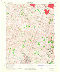
1965 Map of Nicholasville
USGS Topo · Published 1967About this map
The rolling Bluegrass country of Fayette and Jessamine counties is documented here just as suburban Lexington began its southward expansion. Named residential developments like Stonewall Estates, Brigadoon, and Blueberry Hill appear in the northern portion of the sheet, encroaching upon the rural farmsteads that long defined the area. This mid-1960s landscape maintains a balance between the old agricultural economy and new mid-century recreation, featuring both the Waveland Museum and the Blue Grass Raceway. To the south, the city of Nicholasville serves as a dense hub of activity, anchored by the Southern railroad line. The karst topography of the region is evident in the presence of Sinking Creek, while historical local centers like Union Mills and South Elkhorn provide a look at earlier settlement patterns along Hickman Creek and its various branches.
Find a feature on this map
47 named features on this map. Tap any name to fly to it.
Don’t see what you’re looking for? This feature index may not catch every label — zoom into the map to look around manually.
Map Details
Editions of this 1965 Nicholasville Map
4 editions found
Other maps of this area

1892 · Richmond
USGS Topo · 1:125,000

1897 · Richmond
USGS Topo · 1:125,000

1905 · Harrodsburg
USGS Topo · 1:125,000

1906 · Georgetown
USGS Topo · 1:62,500

1908 · Georgetown
USGS Topo · 1:62,500

1927 · Lexington
USGS Topo · 1:48,000

1929 · Lexington
USGS Topo · 1:62,500

1950 · Lexington East
USGS Topo · 1:24,000

1950 · Lexington West
USGS Topo · 1:24,000

1952 · Keene
USGS Topo · 1:24,000