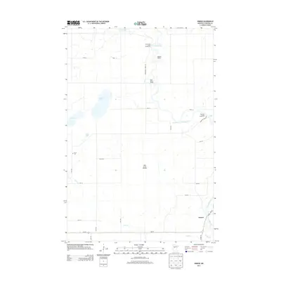
2013 Map of Nimrod
USGS Topo · Published 2013About this map
The Crow Wing River snakes through this landscape in Wadena County, creating distinctive features such as the Kossila Oxbow and several stretches of moving water, including Butterfield Rapids and Walkins Rapids. Near the southern edge, the small settlement of Nimrod sits at the junction of MN-227 and Co HWY 26, positioned where the Cat River flows toward its confluence. The terrain is defined by a high concentration of wetlands and small lakes like Rice Lake, Mud Lake, and Yaeger Lake, alongside the sprawling Wire Grass Meadow. Local history and recreation are centered around sites like the Finnish Cem and public access points at the Huntersville Forest Campground and Andersons Crossing Campground. The Mary Brown Bridge provides a notable crossing over the river, linking the rural road network that services this wooded and water-rich region of central Minnesota.
Find a feature on this map
31 named features on this map. Tap any name to fly to it.
Don’t see what you’re looking for? This feature index may not catch every label — zoom into the map to look around manually.
Map Details
Editions of this 2013 Nimrod Map
This is the sole edition of this map. No revisions or reprints were ever made.
Other maps of this area

1953 · Brainerd
USGS Topo · 1:250,000

1957 · Brainerd
USGS Topo · 1:250,000

1958 · Brainerd
USGS Topo · 1:250,000

1965 · Brainerd
USGS Topo · 1:250,000

1969 · Menahga
USGS Topo · 1:24,000

1969 · Sebeka
USGS Topo · 1:24,000
1969 · Blue Grass
USGS Topo · 1:24,000
1969 · Nimrod SW
USGS Topo · 1:24,000
1969 · Nimrod
USGS Topo · 1:24,000

1969 · Burgen Lake
USGS Topo · 1:24,000