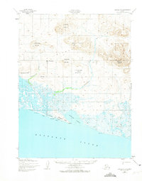
1952 Map of Noatak A-3
USGS Topo · Published 1974About this map
The Kotzebue Sound coastline dominates the southern portion of this 1952 topographic study, where the salt water meets the sprawling drainage of Aukulak Lagoon. Moving inland, the terrain transitions into a complex network of wetlands and river systems, including the Tukrok River and the Situkuyok River. Human presence is sparsely recorded along the coastal margin, marked only by an Old Camp Site and a Shelter Cabin near the Kilangnak Bluff.
Find a feature on this map
21 named features on this map. Tap any name to fly to it.
Don’t see what you’re looking for? This feature index may not catch every label — zoom into the map to look around manually.
Map Details
Editions of this 1952 Noatak A-3 Map
2 editions found
Other maps of this area

1951 · Noatak
USGS Topo · 1:250,000

1951 · Kotzebue
USGS Topo · 1:250,000

1951 · Kotzebue D-2
USGS Topo · 1:63,360

1952 · Noatak A-3
USGS Topo · 1:63,360
1952 · Noatak A-4
USGS Topo · 1:63,360

1955 · Noatak
USGS Topo · 1:250,000

1955 · Noatak B-3
USGS Topo · 1:63,360

1955 · Noatak B-4
USGS Topo · 1:63,360

1955 · Noatak B-2
USGS Topo · 1:63,360
1955 · Noatak A-2
USGS Topo · 1:63,360