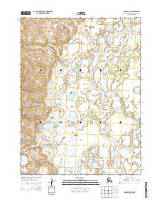
2015 Map of Noatak B-3 NE
USGS Topo · Published 2015About this map
The braided channels of the Noatak River dominate this landscape, winding through the vast river basin where it meets the Eli River in the northeast corner of the sheet. The southwestern portion of the map covers part of the Cape Krusenstern National Monument, a protected area significant for its archaeological and ecological value. The terrain is characterized by a dense network of small ponds and wetlands, illustrating the complex hydrology of the Northwest Arctic. This map documents the area as surveyed in the early twenty-first century, reflecting a remote wilderness where natural features and federal land boundaries, such as those within the Cape Krusenstern National Monument, define the geographic layout rather than human infrastructure.
Find a feature on this map
7 named features on this map. Tap any name to fly to it.
Don’t see what you’re looking for? This feature index may not catch every label — zoom into the map to look around manually.
Map Details
Editions of this 2015 Noatak B-3 NE Map
This is the sole edition of this map. No revisions or reprints were ever made.
Other maps of this area

1951 · Noatak
USGS Topo · 1:250,000

1955 · Noatak
USGS Topo · 1:250,000

1955 · Noatak C-2
USGS Topo · 1:63,360

1955 · Noatak B-3
USGS Topo · 1:63,360

1955 · Noatak C-3
USGS Topo · 1:63,360

1955 · Noatak B-2
USGS Topo · 1:63,360

1964 · Noatak
USGS Topo · 1:250,000
2015 · Noatak C-3 SE
USGS Topo · 1:25,000
2015 · Noatak B-3 SW
USGS Topo · 1:25,000
2015 · Noatak B-3 NW
USGS Topo · 1:25,000