
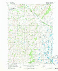
1955 Map of Noatak C-3
USGS Topo · Published 1970About this map
The Mulik Hills dominate this interior landscape, a region of the Arctic defined by a complex network of glacial tributaries and meandering water bodies. Based on 1952 aerial photography and 1955 field annotations, this map captures the remote expanse before modern infrastructure reached the area. The Noatak River flows through the southeastern corner, serving as a primary corridor for the region's movement. Further north, the Kiyak Creek and Kuchoruk Creek carve through the terrain, illustrating the intricate drainage patterns of the tundra. Small clusters of Cabins near the riverbanks provide evidence of seasonal occupancy or subsistence outposts, offering a rare glimpse into the mid-century human footprint in this part of the Northwest Arctic. This sheet highlights the transition between the rolling uplands and the broader river valleys, mapped during a period of extensive photogrammetric survey by the Army Map Service.
Find a feature on this map
9 named features on this map. Tap any name to fly to it.
Don’t see what you’re looking for? This feature index may not catch every label — zoom into the map to look around manually.
Map Details
Editions of this 1955 Noatak C-3 Map
2 editions found
Other maps of this area

1951 · Noatak
USGS Topo · 1:250,000

1955 · Noatak
USGS Topo · 1:250,000

1955 · Noatak D-4
USGS Topo · 1:63,360

1955 · Noatak D-3
USGS Topo · 1:63,360

1955 · Noatak D-2
USGS Topo · 1:63,360

1955 · Noatak C-2
USGS Topo · 1:63,360

1955 · Noatak B-3
USGS Topo · 1:63,360

1955 · Noatak C-4
USGS Topo · 1:63,360

1955 · Noatak B-4
USGS Topo · 1:63,360

1955 · Noatak B-2
USGS Topo · 1:63,360