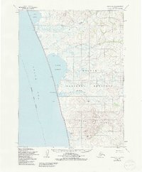
1955 Map of Noatak B-4
USGS Topo · Published 1991About this map
The Chukchi Sea coastline defines this portion of the Northwest Arctic Borough, where the land meets a series of brackish lagoons and tidal inlets. This mid-century coastal survey reveals a landscape largely integrated into what is now the Noatak National Preserve, characterized by the elevation of the Igychuk Hills and Kakagrak Hills. Human presence is marked by isolated structures and infrastructure, including several cabins and a Winter Trail that traverses the lowlands between Imik Lagoon and Kotlik Lagoon.
Find a feature on this map
18 named features on this map. Tap any name to fly to it.
Don’t see what you’re looking for? This feature index may not catch every label — zoom into the map to look around manually.
Map Details
Editions of this 1955 Noatak B-4 Map
2 editions found
Other maps of this area

1951 · Noatak
USGS Topo · 1:250,000

1952 · Noatak A-3
USGS Topo · 1:63,360
1952 · Noatak A-4
USGS Topo · 1:63,360
1952 · Noatak C-5
USGS Topo · 1:63,360

1955 · Noatak
USGS Topo · 1:250,000

1955 · Noatak B-3
USGS Topo · 1:63,360

1955 · Noatak C-4
USGS Topo · 1:63,360

1955 · Noatak C-3
USGS Topo · 1:63,360

1955 · Noatak B-4
USGS Topo · 1:63,360

1964 · Noatak
USGS Topo · 1:250,000