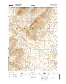
2014 Map of Noatak C-3 NE
USGS Topo · Published 2014About this map
Kiyak Cr and Kuchak Cr define the high-altitude drainage patterns of this remote Northwest Arctic landscape. Surveyed in the early 21st century, the terrain is characterized by steep elevation changes and a complex system of seasonal and perennial waterways. The map illustrates the hydrological divide between these two primary water bodies and the southern Kuchoruk Cr. The absence of roads or permanent settlements within the t27n r20w and t26n r20w townships reflects the preservation of the natural Arctic environment. Researchers can trace the fine-grained contour intervals that reveal the intricate landforms and watershed boundaries unique to this northern borough, providing a clear record of the untouched topography during this period.
Find a feature on this map
7 named features on this map. Tap any name to fly to it.
Don’t see what you’re looking for? This feature index may not catch every label — zoom into the map to look around manually.
Map Details
Editions of this 2014 Noatak C-3 NE Map
This is the sole edition of this map. No revisions or reprints were ever made.
Other maps of this area

1951 · Noatak
USGS Topo · 1:250,000

1955 · Noatak
USGS Topo · 1:250,000

1955 · Noatak D-3
USGS Topo · 1:63,360

1955 · Noatak D-2
USGS Topo · 1:63,360

1955 · Noatak C-2
USGS Topo · 1:63,360

1955 · Noatak C-3
USGS Topo · 1:63,360

1964 · Noatak
USGS Topo · 1:250,000
2014 · Noatak D-3 SE
USGS Topo · 1:25,000
2014 · Noatak C-3 NW
USGS Topo · 1:25,000
2014 · Noatak D-3 SW
USGS Topo · 1:25,000