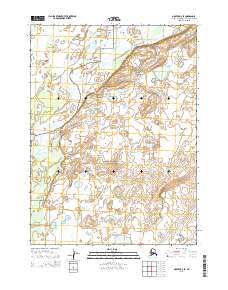
2015 Map of Noatak D-2 SE
USGS Topo · Published 2015About this map
Noatak National Preserve encompasses the entirety of this landscape, where the wide, winding course of the Noatak River dominates the western half of the terrain. The river is flanked by complex networks of oxbow lakes, abandoned channels, and seasonal ponds that define the floodplains in this portion of the Northwest Arctic. The topography transitions from the low-lying wetlands of the river valley to higher ground in the east, where the land is punctuated by countless small, unnamed kettle lakes and drainage patterns. This 2015 survey, published by the U.S. Geological Survey, meticulously details the public land survey system divisions including t28n r18w and t29n r18w, illustrating how the waterway and the surrounding tundra are segmented in one of the most remote regions of the American Arctic.
Find a feature on this map
8 named features on this map. Tap any name to fly to it.
Don’t see what you’re looking for? This feature index may not catch every label — zoom into the map to look around manually.
Map Details
Editions of this 2015 Noatak D-2 SE Map
This is the sole edition of this map. No revisions or reprints were ever made.
Other maps of this area

1951 · Noatak
USGS Topo · 1:250,000

1955 · Noatak
USGS Topo · 1:250,000

1955 · Noatak D-1
USGS Topo · 1:63,360

1955 · Noatak D-2
USGS Topo · 1:63,360

1955 · Noatak C-2
USGS Topo · 1:63,360

1955 · Noatak C-1
USGS Topo · 1:63,360

1964 · Noatak
USGS Topo · 1:250,000
2015 · Noatak C-1 NW
USGS Topo · 1:25,000
2015 · Noatak C-2 NE
USGS Topo · 1:25,000
2015 · Noatak C-2 NW
USGS Topo · 1:25,000