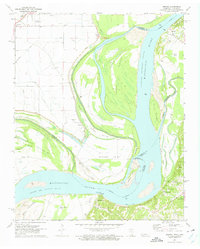
1972 Map of Nodena
USGS Topo · Published 1975About this map
The Mississippi River creates a complex, shifting landscape where Lauderdale Co and Tipton Co, Tennessee, meet Arkansas. The river’s path is defined by a series of islands and chutes, including the Sunrise Towhead Chute and the Towhead of Island No 34. High ground is found along the Chickasaw Bluff No 1 and Chickasaw Bluff No 2, providing stability for settlements like Randolph and Fulton while the floodplain is marked by an extensive system of levees and drainage ditches.
Find a feature on this map
53 named features on this map. Tap any name to fly to it.
Don’t see what you’re looking for? This feature index may not catch every label — zoom into the map to look around manually.
Map Details
Editions of this 1972 Nodena Map
2 editions found
Other maps of this area

1931 · Jericho
USGS Topo · 1:62,500

1939 · Jericho
USGS Topo · 1:62,500

1939 · Evadale
USGS Topo · 1:62,500

1942 · Millington
USGS Topo · 1:62,500

1952 · Jericho
USGS Topo · 1:62,500

1953 · Memphis
USGS Topo · 1:250,000

1956 · Evadale
USGS Topo · 1:62,500

1956 · Memphis
USGS Topo · 1:250,000

1956 · Blytheville
USGS Topo · 1:250,000

1959 · Blytheville
USGS Topo · 1:250,000