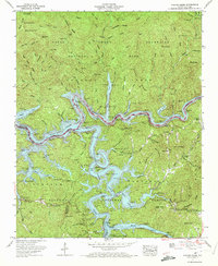
1961 Map of Noland Creek
USGS Topo · Published 1972About this map
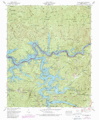
Great Smoky Mountains National Park and Nantahala National Forest converge on this 1961 survey, showing a landscape transformed by the waters of the Fontana Lake reservoir. The junction of the Tuckasegee River and the Little Tennessee River is submerged here, with several floating moorages like Alarka Dock and Greasy Branch Dock serving the recreation-based economy of the mid-century. Genealogists can locate family burial grounds such as McClure Cem and Jenkins Cem, which remain as markers of the communities established before the terrain was flooded. Steep ridges such as Forney Ridge and Welch Ridge tower over the shoreline, leading up to landmarks like the High Rocks Lookout Tower. The map also captures the settlement of Bushnell and the rural congregation at Mt Zion Ch.
Find a feature on this map
69 named features on this map. Tap any name to fly to it.
Don’t see what you’re looking for? This feature index may not catch every label — zoom into the map to look around manually.
Map Details
Editions of this 1961 Noland Creek Map
5 editions found
Other maps of this area

1886 · Knoxville
USGS Topo · 1:125,000

1891 · Cowee
USGS Topo · 1:125,000

1892 · Knoxville
USGS Topo · 1:125,000

1893 · Mt Guyot
USGS Topo · 1:125,000

1894 · Knoxville
USGS Topo · 1:125,000

1895 · Knoxville
USGS Topo · 1:125,000

1897 · Cowee
USGS Topo · 1:125,000

1901 · Knoxville
USGS Topo · 1:125,000

1907 · Cowee
USGS Topo · 1:125,000

1912 · Mt Guyot
USGS Topo · 1:125,000