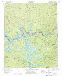
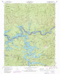
1961 Map of Noland Creek
USGS Topo · Published 1978About this map
Fontana Lake dominates this mountain landscape, its sinuous shoreline and deep inlets reaching into the valleys where the Little Tennessee River and Tuckasegee River meet. This terrain is defined by the high ridges of the Great Smoky Mountains National Park to the north and the Nantahala National Forest to the south. The mapping reveals a distinct pattern of floating moorage and seasonal docks, such as the Alarka Dock and Greasy Branch Dock, which support the recreational use of the reservoir. For genealogists, the map preserves the locations of several family-named burial grounds, including the Woody Cem and McClure Cem, often located on hillsides overlooking the flooded river valleys. Along the southern edge, the Southern RR tracks follow the contours of the land near Mt Zion Ch, tracing the industrial and spiritual geography of Swain County.
Find a feature on this map
85 named features on this map. Tap any name to fly to it.
Don’t see what you’re looking for? This feature index may not catch every label — zoom into the map to look around manually.
Map Details
Editions of this 1961 Noland Creek Map
5 editions found
Other maps of this area

1886 · Knoxville
USGS Topo · 1:125,000

1891 · Cowee
USGS Topo · 1:125,000

1892 · Knoxville
USGS Topo · 1:125,000

1893 · Mt Guyot
USGS Topo · 1:125,000

1894 · Knoxville
USGS Topo · 1:125,000

1895 · Knoxville
USGS Topo · 1:125,000

1897 · Cowee
USGS Topo · 1:125,000

1901 · Knoxville
USGS Topo · 1:125,000

1907 · Cowee
USGS Topo · 1:125,000

1912 · Mt Guyot
USGS Topo · 1:125,000