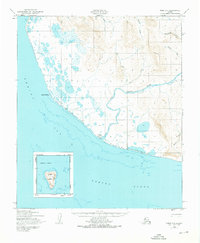
1950 Map of Nome C-3
USGS Topo · Published 1976About this map
Sinuk Roadhouse stands as a focal point of human settlement on this Seward Peninsula coastline, positioned where the Sinuk River meets the Bering Sea. Photographed in 1950, this landscape reveals a transition from the coastal plains and marshy lowlands near Cape Rodney to the rising interior terrain drained by Independence Creek and Stuart Creek. The presence of the Winter Trail running parallel to the shore illustrates the historical importance of seasonal travel routes in this part of Alaska before modern road infrastructure. To the south, an inset details the isolated topography of Sledge Island within Norton Sound, providing a clear record of the maritime and terrestrial geography of the Nome region at mid-century.
Find a feature on this map
14 named features on this map. Tap any name to fly to it.
Don’t see what you’re looking for? This feature index may not catch every label — zoom into the map to look around manually.
Map Details
Editions of this 1950 Nome C-3 Map
2 editions found
Other maps of this area

1950 · Nome D-2
USGS Topo · 1:63,360

1950 · Nome D-4
USGS Topo · 1:63,360

1950 · Nome
USGS Topo · 1:250,000
1950 · Nome C-3
USGS Topo · 1:63,360

1950 · Nome D-3
USGS Topo · 1:63,360

1950 · Nome C-2
USGS Topo · 1:63,360

1951 · Nome
USGS Topo · 1:250,000

1957 · Nome
USGS Topo · 1:250,000
1975 · Nome C-3
USGS Topo · 1:63,360
2017 · Nome C-2 NW
USGS Topo · 1:25,000