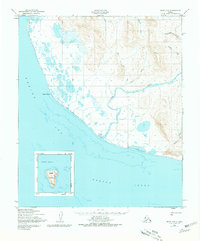
1975 Map of Nome C-3
USGS Topo · Published 1981About this map
Sinuk (Roadhouse) stands as a lonely outpost along the southern coast of the Seward Peninsula in this 1970s-era topographic study. The landscape is defined by the broad delta of the Sinuk River as it meets the Norton Sound, a region shaped by glacial runoff and coastal weather. Evidence of seasonal travel is preserved through the Winter Trail, which parallels the shoreline of the Bering Sea, passing through Cape Rodney toward the northwestern interior.
Find a feature on this map
17 named features on this map. Tap any name to fly to it.
Don’t see what you’re looking for? This feature index may not catch every label — zoom into the map to look around manually.
Map Details
Editions of this 1975 Nome C-3 Map
This is the sole edition of this map. No revisions or reprints were ever made.
Other maps of this area

1950 · Nome D-2
USGS Topo · 1:63,360

1950 · Nome D-4
USGS Topo · 1:63,360

1950 · Nome
USGS Topo · 1:250,000
1950 · Nome C-3
USGS Topo · 1:63,360

1950 · Nome D-3
USGS Topo · 1:63,360

1950 · Nome C-2
USGS Topo · 1:63,360

1951 · Nome
USGS Topo · 1:250,000

1957 · Nome
USGS Topo · 1:250,000
2017 · Nome C-2 NW
USGS Topo · 1:25,000
2017 · Nome D-2 SW
USGS Topo · 1:25,000