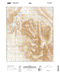
2017 Map of Nome D-3 NE
USGS Topo · Published 2017About this map
The Tisuk River winds through this portion of the Seward Peninsula, carving a path through a landscape defined by prominent peaks and an intricate network of drainage creeks. This coastal interior region is anchored by the elevations of Grand Singatook and Little Singatook, which overlook a series of watercourses including Eldorado Cr and Seattle Cr. The terrain illustrates a remote wilderness where land-use is concentrated along the primary transportation artery, the Nome-Teller Highway/Bob Blodgett Highway, which provides the only major vehicle access through these townships.
Find a feature on this map
22 named features on this map. Tap any name to fly to it.
Don’t see what you’re looking for? This feature index may not catch every label — zoom into the map to look around manually.
Map Details
Editions of this 2017 Nome D-3 NE Map
This is the sole edition of this map. No revisions or reprints were ever made.
Other maps of this area

1950 · Nome D-2
USGS Topo · 1:63,360

1950 · Nome
USGS Topo · 1:250,000

1950 · Teller
USGS Topo · 1:250,000

1950 · Teller A-2
USGS Topo · 1:63,360

1950 · Nome D-3
USGS Topo · 1:63,360

1950 · Teller A-3
USGS Topo · 1:63,360

1951 · Nome
USGS Topo · 1:250,000

1951 · Teller
USGS Topo · 1:250,000

1957 · Nome
USGS Topo · 1:250,000

1957 · Teller
USGS Topo · 1:250,000