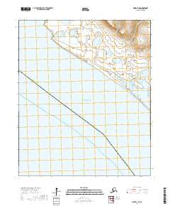
2017 Map of Nome D-4 NE
USGS Topo · Published 2017About this map
Cape Douglas marks the rugged coastline of the Seward Peninsula where the land meets the cold waters of Norton Sound. This 2017 survey documents a landscape dominated by intricate drainage systems, featuring Sourdough Cr, Spruce Cr, and Sullivans Blough Creek. The terrain is characterized by expansive wetlands and low-lying coastal plains, with the Nome Census Area boundary bisecting the southwestern portion of the map. The spatial distribution of these waterways reveals the natural runoff patterns toward the sound, highlighting the importance of seasonal creeks like Peluk Cr in this northern environment.
Find a feature on this map
12 named features on this map. Tap any name to fly to it.
Don’t see what you’re looking for? This feature index may not catch every label — zoom into the map to look around manually.
Map Details
Editions of this 2017 Nome D-4 NE Map
This is the sole edition of this map. No revisions or reprints were ever made.
Other maps of this area

1950 · Nome D-4
USGS Topo · 1:63,360

1950 · Nome
USGS Topo · 1:250,000

1950 · Teller
USGS Topo · 1:250,000

1950 · Nome D-3
USGS Topo · 1:63,360

1950 · Teller A-3
USGS Topo · 1:63,360

1950 · Teller A-4
USGS Topo · 1:63,360

1951 · Nome
USGS Topo · 1:250,000

1951 · Teller
USGS Topo · 1:250,000

1957 · Nome
USGS Topo · 1:250,000

1957 · Teller
USGS Topo · 1:250,000