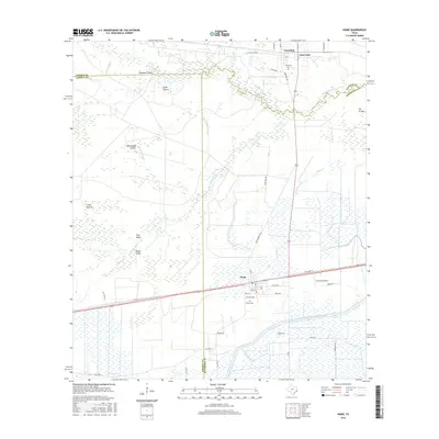
2016 Map of Nome
USGS Topo · Published 2016About this map
Pine Island Bayou meanders along the boundary of Hardin and Jefferson Counties, defining a landscape of low-lying prairies and seasonal sloughs in Southeast Texas. This 2016 survey documents the rural character of the region, where wide-open spaces like Swift Prairie and Whitehead Prairie are interspersed with complex drainage systems including Merchant Slough and Six-Ten Slough. The settlement of Nome serves as a local hub near the southern edge, while the historic communities of Sour Lake and Grayburg sit near the northern border. Cultural and genealogical markers are prominent, with the Grayburg Cem, Berry Cem, and Pivoto Cem providing vital points for family history research. Modern infrastructure is represented by the Lower Neches Valley Authority Canal, reflecting the area's ongoing management of water resources for agriculture and industry.
Find a feature on this map
53 named features on this map. Tap any name to fly to it.
Don’t see what you’re looking for? This feature index may not catch every label — zoom into the map to look around manually.
Map Details
Editions of this 2016 Nome Map
This is the sole edition of this map. No revisions or reprints were ever made.
Other maps of this area

1943 · Whites Bayou
USGS Topo · 1:24,000

1943 · Liberty
USGS Topo · 1:125,000

1945 · Nolte
USGS Topo · 1:31,680

1950 · Houston
USGS Topo · 1:250,000

1954 · Beaumont
USGS Topo · 1:250,000

1955 · Daisetta
USGS Topo · 1:62,500

1955 · Sour Lake
USGS Topo · 1:62,500

1956 · Houston
USGS Topo · 1:250,000

1957 · Beaumont
USGS Topo · 1:250,000
1961 · Whites Bayou
USGS Topo · 1:24,000